
What is the Hydrosat Fusion Hub?#
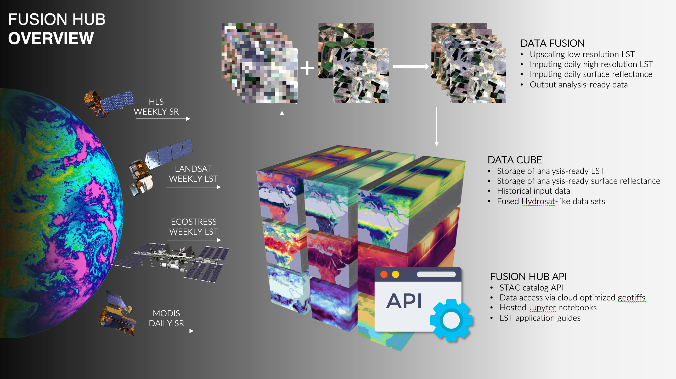
The Hydrosat Fusion Hub generates daily and 20 m resolution Land Surface Temperature (LST) and Normalized Difference Vegetation Index (NDVI) data from a combination of Landsat, MODIS, and Sentinel-2 anywhere on Earth. The data are served through a spatiotemporal asset catalog (STAC) API.
Spatiotemporal data fusion is used to first improve the resolution of the LST data and then to predict high resolution LST values for dates where no higher resolution data are available. The resulting fusion data product and source data are then cataloged in the API for easy access by users. Users may also request access to hosted Jupyter notebooks to use for experimentation with the fusion data.
Hydrosat is soon launching a constellation of TIR+VNIR satellites to provide direct high spatiotemporal measurements. These data will also be available through the Fusion Hub. The addition of Hydrosat constellation data will reduce the need for interpolation and prediction, resulting in enhanced accuracy and traceability.
These data are cutting-edge, providing the requisite resolutions and information needed for monitoring and management critical temperature-related changes such as agricultural heat and water stress, and water use, for example. No other system provides such data.
Getting Started with the Fusion Hub#
Requesting an Account#
When you or your organization complete the agreement to use the Fusion Hub, each named user will receive an email invitation that contains a username, temporary password, and instructions for logging in to change your password. The email will also contain the URLs for the Fusion Hub services.
If your organization already has access to the Fusion Hub, but you do not yet have a user account please request a new user account through your organization’s point of contact with Hydrosat. If you don’t know who your organization point of contact is, please email us at support@hydrosat.com.
If your organization does not yet have access to the Fusion Hub, you can request access by emailing info@hydrosat.com.
Requesting Data#
We currently produce fusion data based on user requests that include:
An area of interest (AOI) provided as a geoJSON, KML, or shapefile.
A time of interest (TOI) provided as a date range (e.g. June 1, 2021 - September 1, 2021)
Your organization may have already provided us with an AOI/TOI, but if you would like to request additional data, please talk to your organization point of contact or send your request including AOI and TOI to support@hydrosat.com.
When Hydrosat receives your request, we will begin creating your dataset. While this is an automated process, it can take a number of hours or even days depending on the size of the dataset and amount of computation required (e.g. currently 6 hours for a single MGRS tile and one month time of interest).
Accessing Data#
All data are provided through a STAC API. Through the API you search for data relevant to your project and access the data from the Hydrosat AWS S3 bucket. Data are stored as Cloud Optimized Geotiffs (COG), so they can either be downloaded in full or directly accessed using HTTP GET range requests.
For more information on STAC see: https://stacspec.org/
For more information on COG see: https://www.cogeo.org/
While you can use the STAC API directly, we recommend using a client library, plugin, or browser. We recommend the following tools.
Python client: stac-utils/pystac-client
QGIS plugin: https://stac-utils.github.io/qgis-stac-plugin/
Web browser: https://rocket.snapplanet.io/home
For more information on how to connect to the API, see our How-To Guides.
Requesting Support#
If you run into any problems using the Fusion Hub services, please get in touch with us at support@hydrosat.com. We’ll get back to you as soon as we can. Our support team is available 9:00 am to 5:00 pm Eastern Time on weekdays.
Known Issues#
The Fusion Hub is in an early development phase and has some issues that we are working to improve. These are the items you should know about when using the service.
Best Efforts - The service is currently provided on a best-efforts basis. We do not provide service level agreements or any guarantees regarding the data and API.
Clouds - Clouds, haze, and smoke can have a significant impact on data availability and data quality. When clouds are present in the source imagery used for fusion they can result in gaps in the data products or even days where no data are available. Clouds can also have an impact on LST accuracy in the final product.
Cloud Mask False Positives - There are false positive detection of clouds in some input data sets, which result in nodata values in the output data sets.
Input Data Coverage - It is often the case that there is not full coverage of a data product extent (MGRS tile) due to the coverage of the input data for a particular date of observation. This can result in nodata areas in the output product.
Input Data Latency - Some of the data sets we use as input to the fusion process are only available days after they are acquired. This can result in latency in producing the latest fusion results. See the product specification for more details.
LST Accuracy - We are continuously working to evaluate and improve LST accuracy, but our early products may have LST errors that are greater than those found in the source data.
LST Bias - The source data we use may have positive or negative LST biases when compared to ground sensors. These biases can make their way into the final product.
Use Case Limitations - The spatiotemporal fusion approach relies on good correlations between observed LST and visible, infrared, and shortwave infrared reflectance (e.g. in vegetation). Certain landcover types or phenomenon may have weaker correlations resulting in greater error in the fusion result. The data products are also limited by the resolution of the source data and very small target or thermal anomalies may not be visible.
Emmissivity Gaps - In certain cases, LST data is not able to be generated from Landsat 8 and Landsat 9 due to gaps in the emmissivity layer used for processing.
If you come across an issue that is not found in this list, please let us know at support@hydrosat.com.