
Hydrosat Daily LST Product Description#
Hydrosat’s LST Fusion Hub produces daily, high resolution gridded Land Surface Temperature data in units Kelvin on a consistent UTM grid for the specified area. When an AOI is specified for processing, all data which overlays the intersecting MGRS grid tile for the area is identified and processed through the sharpening and fusion modules. More detailed descriptions of the product resolution, projection, tiling grid, size, file format, and data type are provided below.
Filename Convention#
The fused LST data will have filenames of the format
<tile>_pred_<yyyymmdd>_from_<yyyymmdd>_using_<coarse_res_data_source>_<high_res_data_source>.tif
where
<tile>- the MGRS tile for which the data was producedpred- signifies the file is a result of predicting LST from the input data sources<yyyymmdd>- the year, month, and day of year for which the data was predictedfrom_<yyyymmdd>- the year, month, and day of year representing the most recent high resolution overpass used to predict the LST.using- the output used the following data sources<coarse_res_data_source>- the data source for the coarse resolution data<high_res_data_source>- the data source for the high resolution data
For example, a file with the name 37PDK_pred_20220629_from_20220617_using_MODIS_Landsat.tif means that for MGRS tile 37PDK, the file contains data representing LST on 2022-06-29 from data on 2022-06-17 using MODIS and Landsat TIRS.
Resolution#
The spatial and temporal resolution of the fused data product is a function of the data specified for the input collections (see Baseline Product).
Spatial#
The spatial resolution of the fused LST product is explicitly tied to the spatial resolution of the high-resolution surface reflectance input. Since the LST Fusion Hub uses all visible and shortwave bands from the Sentinel-2 surface reflectance products as the high-resolution input data, the fused LST product will be 20 m spatial resolution.
The spatial extent of any Fusion Hub processing request is limited to the global land mass and internal waters.
Temporal#
The temporal resolution of the fused LST product is explicitly tied to the availability of the coarse resolution input data products. These data are typically available at a daily cadence; thus, the fused LST data product is produced for every day the coarse resolution data are available. Cloud cover can impact the availability of usable input data products. We will not be able to produce valid output LST for pixels with cloud cover.
The temporal extent of any Fusion Hub processing request is limited to the data availability of the input sources specified for processing. For example, with a combination of data products from MODIS, Landsat 8, and Sentinel-2, the earliest any data could be produced in Fusion Hub is dictated by Sentinel-2’s collection (mid 2015).
Observation Time for Fused Product#
The observation time for the fused output product is the same as the coarse resolution input. For the baseline product, this will be the obersvation time for the MODIS products.
Projection#
The fused LST product is in Universal Transverse Mercator (UTM) projection with the local UTM zone of the AOI specified in the users data request.
Tiling Grid#
Product granule extents are based on Military Grid Reference System (MGRS) 100 km grid. The fused LST product is produced to consume the full MGRS grid tile which contains the AOI specified in the input configuration file.
Size#
A single MGRS grid tile is 109.8 km x 109.8 km, resulting in an individual fused LST product of either 5490 x 5490 pixels (20m spatial resolution) or 10980 x 10980 pixels (10 m spatial resolution). The number of valid pixels defines the file size; for a tile with 100% valid pixels this results in an individual file size of ~210 MB (20 m spatial resolution) of 32-bit floating point values.
File Format#
The fused LST product is stored as Cloud Optimized GeoTIFF (COG) files.
Data Type#
The fused LST product is stored as 32-bit floating point values in units of Kelvin. Pixels which are NoData in the product are stored as the NaN value for 32-bit floating point, i.e., -3.402823466e+38.
Input Data Sources#
The data sources currently available as input data to Fusion Hub processing are summarized in Table 1. The spatial resolution of the fused product will take on that of the highest resolution product specified on input.
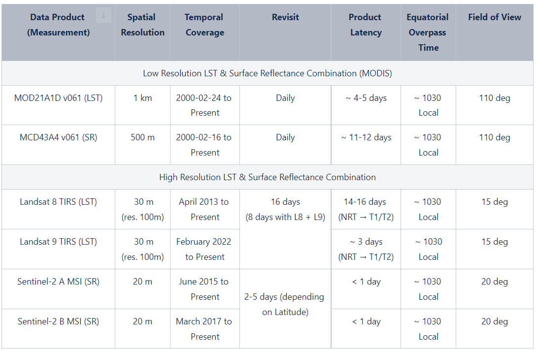
Table 1. Data source pairs available to produce sharpened LST imagery in Hydrosat Fusion Hub. MODIS latency is observed from file availability at https://e4ftl01.cr.usgs.gov/ . Sentinel-2 latencies are observed with the STAC catalog at https://earth-search.aws.element84.com/v0/collections/sentinel-s2-l2a-cogs/items. Landsat latency is taken from Landsat Collection 2 | U.S. Geological Survey (usgs.gov).
Baseline Product#
Assets Description#
LST#
Asset Name: lst
File Type: Cloud Optimized Geotiff
Data Type: Float
Description: The Hydrosat Daily Land Surface Temperature asset described above. Values within this asset represent land surface temperature in Kelvin.
Quality Assurance#
Asset Name: combined_qa
File Type: Cloud Optimized Geotiff
Data Type: Integer
Description: The quality assurance layer that indicates if source data contained cloud, cloud shadow, or other artifacts that may impact the accuracy of the corresponding land surface temperature pixels. For more information see the detailed combined_qa description page.
Preview#
Asset Name: preview
File Type: Cloud Optimized Geotiff
Data Type: Integer
Description: An 8-bit full resolution geotiff preview of the LST asset.
Thumbnail#
Asset Name: thumbnail
File Type: image/png
Data Type: Integer
Description: A reduced resolution 8-bit png preview of the LST asset.
Metadata Description#
STAC Item Metadata#
Each product in the catalog is represented as a STAC Item. An Item is a GeoJSON Feature augmented with metadata fields that describe the product. These include fields that identify the time range and assets of the Item. All core metadata fields can be used as filters during a catalog search.
More information on metadata fields described here can be found in:
Core Item Metadata#
Field Name |
Type |
Description |
|---|---|---|
type |
string |
Type of the GeoJSON Object. |
stac_version |
string |
The version of STAC specification used. |
stac_extensions |
[string] |
Links to the specifications of the STAC extensions used. |
id |
string |
The unique identifier of the Item within the Collection. |
geometry |
Defines the full footprint of the asset(s) represented by this item, formatted according to RFC 7946, section 3.1. Coordinates are specified in Longitude/Latitude or Longitude/Latitude/Elevation based on WGS 84. |
|
bbox |
[number] |
Bounding Box of the asset represented by this Item, formatted according to RFC 7946, section 5. |
properties |
Properties Object |
A dictionary of additional metadata for the Item. |
links |
List of link objects to resources and related URLs. Note that “derived_from” links are links to the intermediate and source products that have been used to produce the Item. |
|
assets |
Map<string, Asset Object> |
Dictionary of asset objects that can be downloaded, each with a unique key. |
collection |
string |
The identifier of the STAC Collection this Item. |
Properties Object Metadata#
Field Name |
Type |
Description |
|---|---|---|
datetime |
string |
The searchable date and time of the asset. For most products, this represents the implied observation/acquisition time. It is formatted according to RFC 3339, section 5.6. |
created |
string |
The time the STAC Item was created. It is formatted according to RFC 3339, section 5.6. |
updated |
string |
The time the STAC Item was last updated. It is formatted according to RFC 3339, section 5.6. |
processing:software |
Map<string, string> |
A dictionary with name/version for key/value describing one or more softwares that produced the data and their version. |
processing:lineage |
string |
Lineage Information provided as text about the how Item assets were processed. |
processing:level |
string |
The name commonly used to refer to the processing level to make it easier to search for product level across collections or items. See the list of STAC defined processing levels. |
proj:epsg |
integer |
EPSG code of the datasource. |
proj:shape |
[integer] |
Number of pixels in Y and X directions for the default grid. |
proj:transform |
[number] |
The affine transformation coefficients for the default grid. |
Asset Object#
Field Name |
Type |
Description |
|---|---|---|
href |
string |
URI to the asset object. |
title |
string |
The displayed title for clients and users. |
description |
string |
A description of the Asset providing additional details, such as how it was processed or created. |
type |
string |
Media type of the asset. |
roles |
[string] |
The semantic roles of the asset, similar to the use of rel in links. |